|Helen Harris (1994) |Phil Newman et al (1999)| |Todd Gray (2001)| |
|
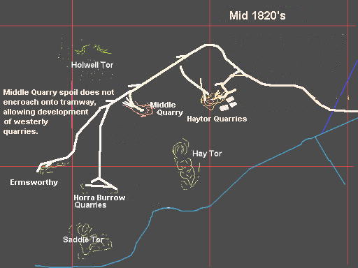
Phase 4, the Western Quarries
The OS map of 1889 shows a tramway with tracks leading west from the viscinity
of Rubble Heap (site 3) and so does the Ewans map
of 1860. Bearne's map of 1840 only shows Middle Quarry, Holwell Quarry and Haytor
Quarry B.
The tramway to the more westerly quarries at Horra Burrow (site 1) and
Ermsworthy (site 2) has been removed. Because of
evidence seen at the rubble heaps of Middle Quarry, the tramway must have been
in use to the westerly quarries at the time Middle Quarry was being exploited.
Therefore these westerly quarries were developed after or around the same time
as Middle Quarry.
The fact that they do not appear on Bearne's map of 1840
is probably because, quarries had been abandoned by then and much of the track lifted for use elsewhere.
|
These quarries were under-worked. As demand for Haytor granite grew, with the
contract for London Bridge won, new resources had to be developed. George Templer
will have been well aware of the resources to the west and thus built a tramway
to them. However these quarries, more notably those at Ermsworthy only exploit
shallow surface ridges and therefore the quality of the stone was not good.
They were therefore abandoned very quickly having been considerably under-worked.
Accommodation for some of the quarrymen was still as it always may have been in the settlement just to the north of Saddle Tor. |