|
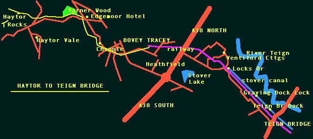
The moorland section of this walk is covered in detail on the Reconstruction
of the Moorland Track and the Extraction and Transportation pages of this
website. Use the Links on the left. We shall pick the track up at the 6
mile marker stone opposite the Bel Alp Hotel just off the road. It is easy
enough to find.
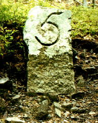
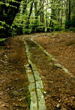
The marker indicates that at this point the tramway is six miles from its destination with the Stover Canal at Teigngrace. From this point the track veers away from the road on its route downhill. What remains of the tramway becomes clearer from here and is fairly easy to follow. Prior to going through a gate to follow the track, on the left are the remains of the last moorland quarry. The track actually runs past the quarry towards Yarner Wood over Long Brake Farm and is not a granite quarry but shale. Whether this quarry has anything to do with the other quarries is open to debate. The quarry face is only small and the rock will have made good building stone for nearby dwellings and walls. The track from here drops down onto the private road leading to Yarner. The track can be picked up again in Yarner Wood. Enter by following the signs by Yarner Lodge. Only a small section of the tramway runs through the wood but it is very well defined, there is also the five mile marker stone to look out for. The track can be followed through the woods before the pathway diverts back onto the main bovey tracey road. the tramway cuts across fields down to the road which runs beside the Edgemoor Hotel. A few setts lie scattered on the lawn of the hotel but the line of the track cannot be distinguished. Head down Chapple Road opposite the hotel and you'll eventually see the tramway emerging from a private wood. It runs along the right hand side of the road to where it crosses Bovey Leat. Here is Chapple Bridge which will have been the only bridge on the tramway until the opening of the second quarry at Holwell Tor. |
|
 |
Follow the pathway just behind the road until it eventually crosses the road, heading off
down another path on the left hand side. The track crosses Brimley and
Ashbuton Roads before running parrallel with Pottery road. Between Ashburton
Road and Pottery Road is the 3 mile milestone on the left hand side of
the track. The remaining 3 miles to Teigngrace have been extensively altered.
You could try and follow the tramway from here trying to pick up traces,
however a more pleasurable exercise would be to head straight for Stover
Country Park and pick up the trail again there.
From the car park be directed by the signs around Stover Lake and through the park. |
| Eventually you'll come to Ventiford Cottages which were built to house employees who worked on the tramway and canal. From here eventually you come to the junction with Teigngrace Road, where you pass under a railway bridge. A little further down the road is a second bridge. Granite Setts can clearly be seen in the construction of this second bridge. The footpath under the bridge passes a wooden bridge on the left and opposite can be seen two small gates leading into a small meadow. This was the start of the Stover Canal forming the circular basin where the barges were loaded and turned. |
|
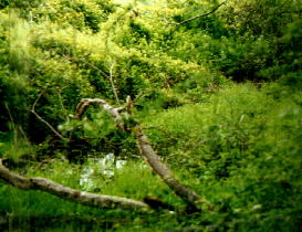
The canal can be seen to run along the eastern edge of the railway line
and is dry in many places only really discernable by a few pools as can
be seen in the picture above. During its lifetime, the canal was about
two miles long and had five locks and two feeders.
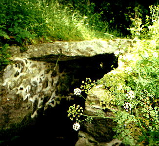
The footpath now takes you away from the canal and along the banks of the River Teign before diverting you back to Teigngrace at locks bridge, where the remains of a 110 ft lock and old canal building can be seen. At Graving Dock Lock a short walk downstream, the lock and gates are seen to be in good condition. this lock was functioning as recently as 1939. This lock incorporated a dry dock for the repair of the barges. |
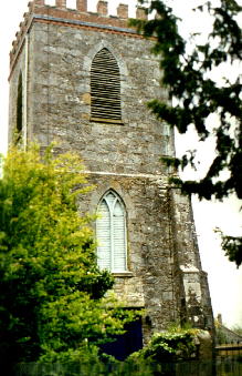
Before heading off to Graving Dock Lock and Teign Bridge take a look at Teigngrace
Church, built of Haytor Granite by James Templer and his brothers. The
church was built on the site of an earlier church. This church was constructed
in 1787 and originally had a spire.
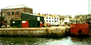
Just under half a mile further on is Teignbridge (SX856733), there
was at one time a lock here, a little way above the bridge. Unfortunately
fill and vegetation have taken their toll, however the bridge is of interest.
It was built in 1798. A scrapyard now occupies the site of stone stable
buildings on the north west side of the bridge. On the south side of the
bridge, the buildings were originally clay cellars.
 |
  |
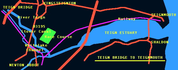
| Another mile south along the footpath will eventually bring you to
the entrance to the Stover Canal from the Teign's Whitelake Channel. This
is a most interesting site and is described well by Teignbridge DCCs Information
board at the site.
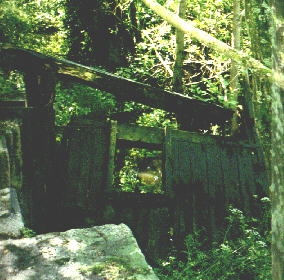
The remnants of the old lower lock just after the entrance can be seen, after which the canal opens out in a basin, possibly to allow further re-loading onto larger river boats. Old mooring posts can be seen along this section of 'quay'. |
|
Beyond the lower lock, a small weir allowed discharge of excess
water. Unfortunately the upper locks bounding this basin have been obscured
by the culvert and railway line, though the entrance to the lock can be
observed.
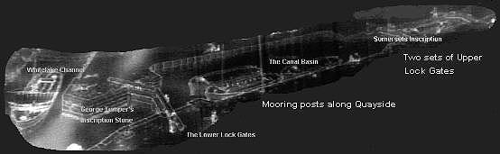
All in all there were two lock chambers and three sets of lock gates. The greyscale schematic shows this well. 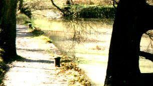 |
The lower gate outside walls bear the inscription, 'GEO TEMPLER
ESQR 1824. This inscription most probably relates to augmentation of the
original earthwork structure with wood and stone. The lower lock was probably
improved prior to the upper locks which show the inscription,'DUKE OF SOMERSET
1841 (no prizes please). The second inscription date ties in nicely with
the fact that the Duke Of Somerset obtained an Act for improving the harbour
at Teignmouth and also Teign navigation in 1936. Helen
Harris mentions that around this time, the canal's first lock was
probably enlarged to form the basin seen today and its walls improved,
hence the plaque.
The grey schematic above is a greyscale photograph of a Teignbridge DC Information Board, that has been altered slightly. Thanks to Teignbridge DC, for giving me permission to do this. |
|
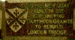
The route continues from here into the Teign Estuary via
the Whitelake Channel and eventually on to New Quay, again built from Haytor
Granite by George Templer in 1821 for the transfer of clay from barges
to coastal ships. A granite plaque in New Quay Street commemorates the
completion of the quay, this marks the end of the Templer Way. Granite
will also have been loaded onto ships here for onward transportation.
A book by Derek Beavis called 'The Templer Way' is a useful guide to anyone wishing to follow the route. It is published by Obelisk Publications (2, Church Hill, Pinhoe, Exeter, Devon). Helen Harris', The Haytor Granite Tramway & Stover Canal is also very informative. The information boards that have been erected along the walk though are superb. Teignbridge DC have asked me to state that this website has nothing to do with themselves, this therefore also applies to Devon County Council and Dartmoor National Park. There are also a number of leaflets available from the local authorities.
There is one called the Templer Way, another in conjunction with the country
park is James Templer's guide to the Heritage Trail and another of less
use is Stover Country Park Information. Most of these can be picked up
from the Information Centres locally. There is one at the car park in Stover
Contry Park and another located in the lower car park at Hay Tor.
Stuart Callon Copyright ©1999 |
|